TAC-C2 (TC2)
TAC-C2 is limited to REC trained pilots. Pilots are to go through the training listed in the document before being operational for OPS/ Multi-VSO events (Unless Prior Permission is given by OPS ADMs)
- List of abbreviations
- Theory
- Tactical Command and Control (TAC-C2)
- Brevity Codes
- PICTURE vs BRAA
- Example of an Intercept
- AC and TAC-P
- SCAR and SAROPS
- Training Layout
- Resources
List of abbreviations
ACA Airspace Controlling Authority
AO Area of Operations
ASAC Airborne Surveillance and Control | Aerospace Surveillance and Control
AWACS Airborne Warning And Control System
BRAA Bearing Range Altitude Aspect
CAS Close Air Support
CRC Control and Reporting Centre
DA Danger Area
ETA Estimated Time of Arrival
JTAC Joint Terminal Attack Controller
KB Kill Box
LR Long Range
NB Nota bene
OSC On Scene Commander
SAROPS Search And Rescue Operations
SCAR Strike Co-ordination and Reconnaissance
SUA Special Use Airspace
TAC- C2 Tactical Command and Control
TAC - P Tactical Air Control Party
TLS Tactical Landing Site
TTO Tactical Transport Operations
VATSIM Virtual Air Traffic Simulation Network
VSO Virtual Special Operations
Theory
Tactical Command and Control (TAC-C2)
Tactical Command and Control (TAC-C2)
TAC-C2 is an overarching term used to encompass AWACS, ASAC and Airspace Control in a tactical environment. It is not necessarily related to the provision of Air Traffic Control Services. Within the VATSIM environment AWACS and Airspace Control assets are subordinate to Air Traffic Control Services, and any instructions from relevant ATC Units are to be followed over and above guidance from AWACS and Airspace Control.
AWACS
AWACS is an airborne radar platform that is predominantly tasked with providing situational awareness of an AO to all users. It is also tasked with providing fighter intercept control and defensive operational information.
ASAC
ASAC is an abbreviation used in two distinctly different environments / purposes.
-
Aerospace Surveillance and Control
-
This is the Royal Air Force ground based Air Defence system based at CRC Boulmer (CRC Boulmer).
-
This element is responsible for enforcing UK airspace, monitoring traffic entering the UK and implementing Quick Reaction Alert protocols when required.
-
In terms of aircraft control, this unit provides fighter intercept control services
-
A deployed element (1 Air Control Centre) carries out the above tasks in deployed locations
-
Airborne Surveillance and Control
-
This is the Royal Navy Shipborne AWACS element utilising the Merlin ASaC Helicopter with the Crowsnest system.
-
This provides the same services as AWACS relating to deployed fleet operations.
Airspace Control
Airspace Control activities are non-Air Traffic Control services that are provided by tactical aircraft to enhance deconfliction in congested airspace where multiple aircraft of same or varying types are expected to require operation. Examples of such Airspace Control include, but are not limited to:
-
Close Air Support operations in support of ground forces
-
Tactical Transport operations
-
Search and Rescue On Scene Commander
Procedures
The Aircraft providing these tasks will inform the VATSIM UK Controllers of their presence, the area in use, airspace activated, expected airframes, aircraft callsigns and the frequency that is going to be utilised. Controllers should approve a frequency change to the approved frequency utilised by the AWACS/ACA once the aircraft enters the AWACS/ACA airspace.
Controllers of sectors adjacent to the area of operations will adapt to direct any non-
participating traffic around the area to minimise disruption to the VSOs activities. Yet, it is
acknowledged that this isn't always possible. If this is the case, then the AWACS/ACA pilot is to be informed of the conflicting aircraft and will then pass this on to all players.
Brevity Codes
Brevity codes are used to keep communication brief and concise while delivering as much information as possible.
See below some of the more commonly used TAC-C2 Brevity Codes.
|
Code |
Meaning |
|
ABORT |
Cease action or terminate the attack prior to weapons release or event or mission. |
|
ALPHA CHECK |
Request for confirmation of bearing and range from aircraft to described point. |
|
ANGELS |
Height of FRIENDLY aircraft in thousands of feet from mean sea level (MSL). |
|
AS FRAGGED |
Unit or element will be performing exactly as briefed or scheduled. |
|
AZIMUTH |
A picture label describing two GROUPS separated laterally. GROUP names will be referenced by cardinal directions |
|
BASE [+/- number] |
Reference number used to indicate such information as headings, altitude, fuels, etc |
|
BINGO |
Prebriefed fuel state needed for recovery. |
|
BOGEY DOPE |
Request for information on indicated or closest GROUP in bearing, range, altitude, and aspect (BRAA) format (with appropriate fill-ins). |
|
BREAK [direction] |
Perform an immediate maximum performance turn in the indicated direction (default is a 180-degree turn). |
|
BUSTER |
Fly at maximum continuous speed |
|
CLEARED TO ENGAGE |
Clearance to fire on designated GROUP or target. |
|
COMMIT |
Intercept the GROUP(S) of interest. NB: Does not indicate authority to release weapons |
|
CONTACT |
Sensor information at the stated position. |
|
DECLARE |
Inquiry as to the ID of specified track(s), target(s), or correlated GROUP. Responses may include: FRIENDLY, BOGEY, BANDIT, HOSTILE, NEUTRAL, UNABLE, CLEAN, or FURBALL. |
|
FADED |
Sensor data is lost on GROUP or CONTACT |
|
FAKER |
A FRIENDLY track acting as a HOSTILE for exercise purposes. |
|
GORILLA |
Large force of indeterminate numbers and formation of unknown or non-friendly aircraft. |
|
HOME PLATE |
Home airfield or ship. |
|
ID |
1. Directive call to identify the target or track 2. (type) ID is accomplished, followed by type |
|
JOKER |
Fuel state above BINGO at which separation, BUGOUT, or event termination should begin. |
|
JUDY |
Aircrew has taken control of the intercept and only requires situation awareness information; controller will minimize radio transmissions. |
|
KNOCK-IT-OFF |
Cease all air combat maneuvers, attacks, activities, or exercises (training use only). |
|
MERGE(D) |
FRIENDLIES and targets have arrived in the visual arena. |
|
NO JOY / BLIND |
Aircrew does not have visual contact with the TARGET or BANDIT. Opposite of TALLY. |
|
PEDRO |
Combat search and rescue helicopter. |
PICTURE |
A request to provide information pertinent to the mission in a digital bullseye format unless briefed otherwise. |
|
SNIFF [type] |
Passive sensor indication of a radar emitter. |
|
TALLY |
Sighting of a target, non-friendly aircraft, or enemy position. Opposite of NO JOY. |
|
TARGETED |
Fighter has acquired assigned GROUP and has assumed responsibility for it. |
|
WINCHESTER |
No ordnance remaining. |
|
EMBELLISH |
(UK MMATM Term Only). A codeword signifying that an Aircraft is prepared to act as a target for fighter interception. |
Descriptions of Airborne Tracks
The following descriptor codes will be used to identify TRACK(S)/GROUP(S).
|
Code |
Description |
|
FRIENDLY |
A positively identified FRIENDLY aircraft, ship, spacecraft, or ground position |
|
BANDIT |
Positively identified as an enemy in accordance with (IAW) theater ID criteria. The term does not imply direction or authority to engage. |
|
BOGEY |
A CONTACT whose identity is unknown |
|
STRANGER |
CONTACT not involved in the exercise (Used only in Training) |
|
HOSTILE |
A contact identified as enemy upon which clearance to fire is authorized IAW theater rules of engagement (ROE). |
|
NEUTRAL |
A positively identified aircraft, ship, or ground position whose characteristics, behavior, origin, or nationality indicate it is neither supporting nor opposing FRIENDLY forces |
PICTURE vs BRAA
There are two types of transmission that you will hear from a TAC-C2 controller providing air defence operations:
PICTURE - This is a descriptive overview broadcast aimed for all players on a frequency. Think of it as building a map of the current situation. The main reference is a “BULLSEYE (BULLS)” point, which is a prebriefed location.
BRAA - A descriptive transmission intending for a specific recipient on the frequency providing direct information on a target contact. The reference point for these transmissions is the location of the intended recipient.
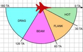
As MSFS systems are not configured to easily support in aircraft BULLSEYE nomination, a BRAA call is likely to be the main type of call used.
Example of an Intercept
In the below example, SOLEX01 is an AWACS aircraft providing UK Air Defence C2. RAZOR11 is a Typhoon aircraft that has just departed on a prebriefed Air Defence sortie. The TRACK is currently a BOGEY.
NB: This is only an example and not every situation will follow this format. It has been adapted for VATSIM.
The prebriefed BASE Altitude is FL250. BULLSEYE is set to RAF Leuchars
RAZOR11: SOLEX01, RAZOR11, Checking in for Mission Number 1234 As Fragged Request Alpha Check.
SOLEX01: RAZOR11, Radar Contact, Squawk 7002, No ATC service provided. HOMEPLATE 034 for 15, ANGELS 15.
RAZOR11: SOLEX01, ALPHA CHECK Confirmed.
SOLEX01: SOLEX01, PICTURE, SINGLE GROUP, BULLSEYE 050, 95, Base+100, South bound, strength 1, BOGEY.
In this example, the BOGEY is on a bearing of 050 degrees from RAF Leuchars at a range of 95 nautical miles. It is at FL350 and is heading roughly South. It is an as yet unidentified track.
As RAZOR11 is specifically tasked for air defence, at this stage, SOLEX01 will start to vector the aircraft and will switch to BRAA calls.
SOLEX01: RAZOR11, vector 030 for BOGEY. BRAA 020, 130, Base +100, South
As the intercept progresses and the BOGEY continues into UK airspace, ELectronic INTelligence (ELINT) information on board the E-3 starts to pick up signals on the BOGEY. This ELINT identifies the aircraft as a Tu-160 Backfire, which by the knowledge of the theatre, identifies that aircraft as a BANDIT.
SOLEX01: RAZOR11, BRAA 030, 80, BASE +100, South, SNIFF BACKFIRE, BANDIT
RAZOR11: RAZOR11, CONTACT
SOLEX01: RAZOR11, Recommend COMMIT, ID
RAZOR11: COMMIT, ID, JUDY
In the above exchange, RAZOR11 has confirmed to SOLEX01 that he has the now BANDIT on radar. In response, SOLEX01 has recommended that he carries out an engagement on the BANDIT to positively identify it. RAZOR11 accepts the COMMIT, confirms it is to ID, and indicates that he has the target on Radar and is taking over the intercept from the controller to self maneuver. At this stage, SOLEX01 will minimise communications.
AC and TAC-P
Airspace Control
In the sphere of TAC-C2, Airspace Control relates to the co-ordination of units to facilitate another operation, usually on the surface. There may be some cross over with TAC-P, especially where TLS or CAS Operations are concerned.
In the event that a TAC-P and AWACS/ASAC positions are utilised, the Airspace Control ACA may be utilised to offload some of the traffic from the AWACS unit within airspace delegated to the ACA without overloading the TAC-P.
As ACAs are predominantly in support of surface operations, these are likely to operate within established SUA, or outside controlled airspace. It is strongly recommended that a NOTAM is published for any operations not operating within SUA.
TAC-P Support
When ACAs are working in support of TAC-Ps, it is imperative that the ACA liaises with the TAC-P to ensure appropriate holds are utilised to keep aircraft clear of the TAC-P AO. This is the same for CAS and TTO.
Ingress and egress routes with nominated visual holds will likely be established and briefed accordingly by the TAC-P to the ACA.
SCAR and SAROPS
SCAR
SCAR is a unique mission set for a TAC-C2 aircraft. This mission will usually be carried out autonomously within a defined geographical area (A DA in training, a KB on Operations) and is split into two specific taskings.
-
Reconnaissance of the AO to identify and classify potential targets
-
“Control” of strike assets designated to the AO
-
Assignment of holding areas and altitudes/levels
-
Dissemination of target information
-
Co-ordination of Strike Aircraft engagements against said targets
Using all available sensors, a SCAR aircraft will usually arrive in their AO ahead of any Strike aircraft. They will scour the AO and identify and classify targets. They will designate priorities against each target in accordance with ROE / Commander’s Intent and compile information to pass to striking aircraft.
As the strike aircraft arrive on scene, they will contact the SCAR platform and will be assigned holding points and altitudes.
The SCAR aircraft will then pass targeting information on targets in the order of priority that they have determined and co-ordinate the utilisation of the AOs airspace to assist the strike aircraft in deconfliction.
It is to be noted that TAC-C2 do not provide JTAC services and must not use JTAC phraseology or clear aircraft for engagement / hot.
The following is an example of a SCAR briefing to a striking aircraft. Upon delivery of the briefing, the striking aircraft is considered released to carry out their attack. There will be no clearances issued by the SCAR. However, they may choose to put restrictive attack headings / altitudes / other measures in place to assist in deconfliction.
NB - See attack brief below.
SAROPS
In the event of protracted or LR SAROPS, TAC-C2 aircraft may act as a SAR OSC.
As an OSC, a TAC-C2 aircraft will usually orbit the SAR scene at a few thousand feet above the surface. This will allow Line of Sight Radio systems to continue to operate whilst also permitting observation of the casualty vessel.
A TAC-C2 aircraft acting as an OSC will keep a record of all assets responding to the scene, ETAs, and act as a communications relay between assets out of line of sight of the casualty vessel and the vessel itself. They will pass traffic information between assets to assist them in deconflicting against each other, but they are not providing any air traffic or separation services.
Training Layout
Training Layout
AWACS / RN ASAC / ACA requirements:
Pilot, Recon Rated, not a controller. Does not provide ATS. Carried out utilising “on board sensors”
CRC Boulmer ASAC requirements:
VATSIM C1, Military Approach Rated. Carried out using a controller client with designated position logon. May provide Air Traffic Services.
AWACS/ASAC Training evolutions:
-
Direct 1 v 1 intercept against a non-maneuvering target with a commit to ID a BOGEY
-
Direct a 1 v 1 intercept against a maneuvering target with a commit to ID a BOGEY
-
Direct a Defensive Counter Air (Combat Air Patrol) against an inbound threat aircraft, utilising Theatre ROE
ACA Training Evolutions
-
Liaise with a TAC-P (can be instructor) to establish airspace in support of TAC-P operations
-
Ideally, minimum of 1 Fast Jet to conduct CAS & 1 Helicopter to Conduct a Tactical Transport sortie
-
Conduct a SCAR sortie within an established Danger Area with at least 1 Fast Jet. Demonstrating Simulated identification of targets (list provided by Instructor), prioritising in accordance with instructions briefed prior to departure. Passing details to strike aircraft.
-
Conduct 1 Simulated SAR OSC task. Support from in house RW assets and/or vHelimed. Ideally, add a fixed wing raft drop from P8/A400 as part of build up.
Resources
Further Brevity Codes
|
FURBALL |
Non Friendly and Friend A/c are within 5nm |
|
ACTION |
Begin a Pre-briefed manoeuvre/attack |
|
SPIKE |
You are being locked |
|
CLEAN, DEFENDING |
No threats / evading threat |
|
HOOK |
Execute 180° turn |
|
LOCKED |
Radar or IR lock Established |
|
MUSIC |
Electonic Jamming detected |
|
ZIPLIP |
Limit transmission to critical info only |
|
LEAKER (S) |
AIrborne Threat has passed through defensive layer |
|
SNAP |
Request immediate BRAA to the specific GROUP, for interception |
|
POST ATTACK |
Desired direction for the FJ to turn on completion of intercept or engagement |
SCAR ATTACK BRIEFING
|
SCAR Attack Briefing |
|
Deconfliction Instructions: “ “ (Block altitudes, keypads/quadrants, georef, flow, timing) Target Description: “ “ Target Location: “ “ (Coordinates, geographic references, etc) Target Elevation: “ “ Remarks: “ “ (Buddy-laze plan, mark, time on target (TOT), threats, UAS, etc.) Example: “JEDI11, SERPENT59, remain in Quadrant 4, Angels 20. Your target is a column of 4 APCs oriented North to South with dismounted infantry, location N3401.034 / W07601.089, elevation 69ft, possible MANPADs, friendly UAS as fragged” |